| 2.7.1 Provision of roads, methods of travel and
the transportation of products and materials are important planning
issues. The Local Plan recognises that transport planning and land
use planning need to be properly integrated. Suffolk County Council
is the Highways Authority and has direct responsibility for maintaining
and improving Suffolk's roads, helping to reduce the environmental
impact of traffic and the number of road accidents and promoting
public transport including subsidising local services. Mid Suffolk
District Council has the more limited responsibility of providing
public car parking. However, Mid Suffolk is the District Planning
Authority and through its planning decisions on development will
have a significant impact on the extent to which existing roads
and public transport are used. Its planning decisions will also
affect where new roads or increased capacities are needed. The production
of the Local Plan has involved close consultation between the District
Planning Authority and the County Highways Authority. |
Working with the County Highways Authority
to plan for future development. |
| 2.7.2 The National Road Traffic Forecasts issued
by the Department of Transport predict that by the year 2025 there
could be 2.5 times as much traffic on all roads as there is in 1992.
Increasing the supply of road space to match the potential growth
in traffic will not address key issues such as environmental sustainability.
Alternative options have to be found. The Government is asking District
Planning Authorities to look at patterns of development which reduce
transport demand, promote opportunities for higher-occupancy public
transport, and encourage cycling and walking particularly in built-up
areas. |
Looking at alternative ways of responding
to traffic growth. |
| 2.7.3 The Transport objectives of the
Local Plan are:-
- to support the provision of a road network that meets
existing and future transport needs in a safe, convenient and
environmentally sustainable manner
- to ensure that proper account is taken of all modes
of transport
- to ensure that the environmental implications of new
road and transport proposals are fully considered
- to plan for a safe and pleasant environment for pedestrians
and cyclist
- to seek a reduction in unnecessary car use, and an
increase in bicycle use and walking, both by making the latter
more attractive and by restraining traffic where appropriate
- to provide an adequate level of public parking facilities
for cars, lorries and cycle
- to ensure that all new development includes proper
arrangements for access and, where appropriate, parking for cars,
lorries and cycles
- to introduce traffic management measures to relieve
congestion and to improve environmental conditions, particularly
for pedestrian
- to use the land-use planning responsibilities of the
District Planning Authority to support Suffolk County Council's
efforts to maintain a convenient public transport service.
|
|
Transport and the Environment |
|
| 2.7.4 The Government wants local authorities to
pursue policies that have the potential to reduce Britain's emissions
of greenhouse gases. Carbon dioxide is the main
greenhouse gas accounting for over 50 per cent of the man-made greenhouse
effect. Transport accounts for 23 per cent of Britain's emissions
of carbon dioxide and yet the demand for personal travel particularly
private and business car travel is greater than ever. People set
great store by the mobility and freedom that cars bring. The speed
and flexibility of motoring make it indispensable for much business
travel which in turn is important for the economy. In 1991, 59 per
cent of freight tonne miles and 93 per
cent of all passenger journeys were made by road. |
Environmental pollution through excessive
traffic generation. |
| 2.7.5 The White Paper 'This Common Inheritance'
states the Government's intention to issue planning guidance on
the location of new development and its effect on traffic generation
as a way of tackling global warming. Preliminary findings from the
Government's consultants, ECOTEC Research and Consulting, confirm
that planning policies currently applied are on lines that keep
transport emissions to a minimum. These policies focus development
in urban areas rather than in villages and new settlements, and
look to revitalise town centres. |
Bringing together planning for new development
and transport. |
| 2.7.6 Concentrating employment and retail uses close
to existing built-up areas more easily served by public transport,
putting most residential development near to transport
nodes and in road corridors, such as the A14, and increasing
the possibilities for people to live near their work all make a positive
contribution to lessening traffic demand. The Local Plan has attached
particular weight to these issues in the way it has put together its
policies and proposals. During the preparation of the Deposit Draft,
PPG13: Transport, was released and offers further
support for this stance. |
|
Mid Suffolk's Road Network |
|
| 2.7.7 Trunk Roads - The
County Highways Authority has a duty to maintain all roads in Suffolk
with the exception of trunk roads. This responsibility lies with
the Department of Transport because of the national importance of
trunk roads as major cross-country routes. Trunk roads carry a high
proportion of through traffic, particularly heavy goods vehicles.
Major roads serving Mid Suffolk and the region are shown in Diagram
5. |
Intended improvements to the Trunk Road
network. |
| 2.7.8 The national roads programme has been subject
to reviews, and several trunk road improvement schemes have been
withdrawn due to lack of resources. Among the schemes withdrawn,
up to and including 1996, have been those in Mid Suffolk ie. A140
Stonham Bypass (and eventual dualling of the A140 from Beacon Hill
Interchange with the A14 to Norwich) and A14 Quarries Cross Improvements
(near Haughley). The Government has advised that where schemes have
been withdrawn, route strategies will be developed to identify smaller
scale improvements, to tackle safety and localised congestion problems. |
|
| 2.7.9 The only remaining trunk road schemes in Suffolk
are the A11 Fiveways Roundabout to Thetford dualling and the A14
Rookery Cross roads grade separated junction at Rougham. The latter
scheme lies outside Mid Suffolk in the Borough of St. Edmundsbury
but the present junction arrangement influences the routes taken
by heavy goods traffic through villages in Mid Suffolk. |
Junction improvements on Trunk Roads in
Mid Suffolk. |
| 2.7.10 County Principal Roads
- The Department of Transport designates a Primary Route
Network consisting of all trunk roads and the more important
principal roads in each County as the route for through traffic
between main built-up areas. The Primary Route Network is distinguished
by green backed direction signs. That part of the Primary Route
Network within Mid Suffolk consists of the A14 and A140 trunk roads
and the A143 from Bury St. Edmunds to Scole. However most of Mid
Suffolk's towns and villages are served by 'B' and 'C' class
roads. |
Priority for road improvements is given
to the Primary Route Network. |
2.7.11 The County Highways Authority produces an
annual statement of its transport policies and priorities for implementation.
This is known as the Transport Policies and Programme
(TPP) and includes a spending programme for the following year which
is submitted to the Government for financial support. The TPP contains
a five year programme of major schemes, each costing more than £1
million. The actual start date for a scheme depends on the Department
of Transport agreeing to contribute to the cost in the form of Transport
Supplementary Grant. |
Major road schemes programmed for Mid Suffolk.
|
| 2.7.12 The proposed Stowmarket B1115 Relief Road
scheme has been included in the County Council's TPP. A "Stowmarket
Transport Fund" has been established to accumulate funds to
be used to bring forward construction of the B1115 Relief Road to
improve accessibility and traffic flow for the eastern part of Stowmarket
and to further link and incorporate the new development area with
the town. The Council's aims and objectives regarding the B1115
Relief Road and the Strategic Development Area are considered fully
in Section 2.10. |
A proposed B1115 Relief Road at Stowmarket.
|
|
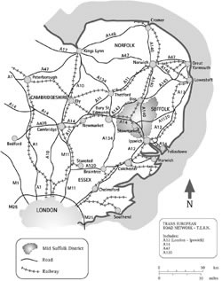
[Click to see larger image in a pop-up window]
Diagram 5 - Principal Road and Rail Links |
|
| 2.7.13 In 1988, the County Highways Authority and
Ipswich Borough Council commissioned a study of traffic problems
in and around Ipswich. The report of their consultants, Halcrow
Fox and Associates, identified options including a Northern Bypass
for Ipswich. The road scheme is not currently programmed and is
not expected to be carried out during the Local Plan period (up
to 2006). |
Northern Bypass for Ipswich. |
ENVIRONMENTAL IMPACT ON MAJOR ROAD SCHEMES
POLICY T1
WHEN CONSIDERING PROPOSALS FOR MAJOR ROAD SCHEMES THE DISTRICT
PLANNING AUTHORITY WILL TAKE ACCOUNT OF THE BENEFITS STEMMING FROM:-
- IMPROVED SAFETY AND THE FREE FLOW OF TRAFFIC;
- IMPROVED ACCESSIBILITY TO INDUSTRIAL AND COMMERCIAL
AREAS THAT CAN BE PROPERLY DEVELOPED IN SUPPORT OF THE LOCAL ECONOMY;
- IMPROVED QUALITY OF LIFE IN SETTLEMENTS WHERE BYPASSES
ARE PROPOSED.
THESE FACTORS WILL BE BALANCED AGAINST ENVIRONMENTAL CONCERNS,
PARTICULARLY THE IMPACT OF ANY MAJOR ROAD SCHEME ON:-
- LANDSCAPE, WILDLIFE AND ARCHAEOLOGY;
- LOCAL HERITAGE ESPECIALLY LISTED BUILDINGS OR CONSERVATION
AREAS;
- BEST AND MOST VERSATILE AGRICULTURAL LAND;
- RESIDENTIAL AMENITY.
|
|
| 2.7.14 Roads in Rural Areas
- The majority of rural roads are proving inadequate for the traffic
now carried. Between 1981 and 1991 the actual growth rate on Suffolk's
roads was over twice the 'high growth' forecast by the then Department
of Transport. Inevitably, rural roads follow ancient field boundaries,
characterised by numerous right-angled bends. They are constantly
in need of structural maintenance which imposes an increasing financial
burden on the County Highways Authority. |
Many rural roads are inadequate to deal
with increased traffic levels. |
| 2.7.15 The preference of hauliers to operate larger
lorries and the need to transport goods and materials to and from
farms and other industries in the countryside causes widespread damage
to road surfaces and verges. The speed of traffic in rural areas,
particularly through villages, causes local concern with most Parish
Councils wishing to see speed limits introduced within the built-up
areas of their villages. |
|
| 2.7.16 The County Highways Authority tries to alleviate
traffic and safety problems in rural areas through its highway improvements
programme. This is set out in the TPP and covers road widening and
bend improvements, the provision of footpaths and the construction
of laybys or passing places. In addition, lorry management plans,
like that applying to the A1088, can be developed to accommodate
lorries safely and minimise their impact on rural roads. Mid Suffolk
District Council constructs laybys as part of environmental enhancements
in villages or to overcome parking problems at its own local authority
housing. Traffic management, such as speed limits, lorry controls
or warning and information signs, helps to improve safety and, in
towns, can significantly reduce traffic congestion. The County Highways
Authority can only impose weight restrictions on roads if suitable
alternative routes are available for heavy goods vehicles. |
Minor highway improvements
and traffic management. |
MINOR HIGHWAY IMPROVEMENTS
POLICY T2
THE DISTRICT PLANNING AUTHORITY WILL TAKE ACCOUNT OF ROAD
SAFETY AND MINOR WORKS SCHEMES INCLUDED IN THE ANNUAL TRANSPORT
POLICIES AND PROGRAMME WHERE THEY HAVE A MATERIAL EFFECT ON A PLANNING
APPLICATION. WHILST HAVING REGARD TO ENVIRONMENTAL CONSIDERATIONS,
ATTENTION WILL BE GIVEN TO SECURING HIGHWAY IMPROVEMENTS THAT BRING
BENEFIT TO TRAFFIC AND PEDESTRIAN SAFETY. |
|
| Note: Road safety may
be improved by virtue of the Minor Works schemes identified
in the Suffolk County Council Transport Policies and Programme.
These schemes may include improvements to carriageway alignment,
provision of new footways, laybys and street lighting. |
|
|
TRAFFIC MANAGEMENT
POLICY T3
THE DISTRICT PLANNING AUTHORITY WILL WORK WITH THE COUNTY
HIGHWAYS AUTHORITY TOWARDS THE INTRODUCTION OF TRAFFIC MANAGEMENT
MEASURES, SUCH AS SPEED LIMITS IN VILLAGES OR WEIGHT RESTRICTIONS
ON MINOR ROADS, WHERE THIS WILL HELP TO MAINTAIN AND IMPROVE TRAFFIC
AND PEDESTRIAN SAFETY AND TO IMPROVE ENVIRONMENTAL CONDITIONS, INCLUDING
RESIDENTIAL AMENITY. |
|
| 2.7.17 Highways Infrastructure and Developer
Contributions - Highways form an important part of
the infrastructure needed for development to take place. The capacity
of existing highways infrastructure and the need for new roads has
been taken into account in preparing the Local Plan so that new
development can be co-ordinated with the infrastructure it demands.
Decisions on individual planning applications similarly need to
bear in mind existing or programmed infrastructure. When it comes
to an individual planning application, the adequacy of infrastructure
can be a material consideration in deciding whether permission should
be granted. Where limitations in the local road network would prevent
development taking place that would in other respects be acceptable,
the problem may be overcome if the developer is willing to enter
into an obligation to pay for a necessary highways improvement or
to contribute towards the cost of bringing forward the start date
of a programmed highways scheme. |
Developer initiatives to overcome highway
constraints. |
| 2.7.18 Traffic in Stowmarket
- The A1308 Inner Relief Road was completed in August 1992 and provides
relief for the town centre from traffic travelling in a north-south
direction. The peak hour congestion that occurs presents a particular
problem for east-west movements across town when combined with the
level crossing which restricts the flow of traffic using the B1115.
The District Planning Authority supports the provision of a relief
road for the B1115 incorporating a rail and river bridge crossing
and connecting to the A1308. This scheme is also required as part
of the infrastructure to link the Strategic Development Area (SDA)
with the town (this is further explained in Section 2.10, and Policies
SDA1 and SDA2 relate). |
|
| 2.7.19 The B1115 relief road will contribute, in part,
to assisting east-west flows of traffic across town, and the town
centre and new development/redevelopment outside the SDA will also
benefit. The limitations of the existing highway network are a constraint
on further development in Stowmarket and the provision of the B1115
relief road and the effects of the new junction of this road with
the A1308 will be a major consideration for applications for development
or redevelopment proposals in the town during the Plan period. Such
applications will be required to provide the results of Traffic Impact
Studies to help assess the effect of additional traffic movements
within the town. In addition to Policy T4 a complementary policy is
included to address the particular difficulties of traffic generation
on flows within the town of Stowmarket. |
|
PLANNING OBLIGATIONS AND HIGHWAYS INFRASTRUCTURE
POLICY T4
WHERE DEVELOPMENT CANNOT BE PERMITTED UNLESS HIGHWAY IMPROVEMENTS
ARE UNDERTAKEN, DEVELOPERS MAY ENTER INTO A PLANNING OBLIGATION
UNDER SECTION 106 OF THE TOWN AND COUNTRY PLANNING ACT 1990 (AS
AMENDED) OR AN AGREEMENT UNDER SECTION 278 OF THE HIGHWAYS ACT 1990
OR OTHER RELEVANT STATUTE, TO FUND, OR MAKE A CONTRIBUTION TOWARDS,
THE COST OF SUCH HIGHWAY IMPROVEMENTS.
IN NO CIRCUMSTANCES WILL THE DISTRICT PLANNING AUTHORITY
VIEW THE OFFER OF INFRASTRUCTURE IMPROVEMENTS OR OTHER BENEFITS
AS REASONS TO PERMIT A PLANNING APPLICATION FOR DEVELOPMENT WHICH
IS CLEARLY CONTRARY TO PLANNING POLICY OR OTHERWISE UNACCEPTABLE
FOR LAND USE OR ENVIRONMENTAL REASONS. |
|
| Note: In considering planning
applications under this policy, the District Planning Authority
will have regard to Annex B of Department of the Environment
Circular 1/97 on Planning Obligations. |
|
|
FINANCIAL CONTRIBUTIONS TO B1115 RELIEF ROAD
POLICY T5
THE DISTRICT PLANNING AUTHORITY WILL SEEK TO NEGOTIATE
FINANCIAL CONTRIBUTIONS TO THE B1115 RELIEF ROAD SCHEME AND SUCH
OTHER MEASURES AS ARE NECESSARY, FROM DEVELOPMENT OR REDEVELOPMENT
PROPOSALS IN STOWMARKET WHICH, FOLLOWING A TRAFFIC IMPACT STUDY,
ARE LIKELY TO RESULT IN AN INCREASE IN CROSS TOWN TRAFFIC. |
|
|
Note: The above policy should be read in conjunction
with Policy T4; paragraphs 2.10.8 and 2.10.13, Policies SDA1
and SDA2; and paragraphs 2.6.35-2.6.36 and Proposal 12. |
|
|
Roadside Services |
|
| 2.7.20 Facilities for road users are increasingly
concentrated alongside trunk roads and other parts of the Primary
Route Network where traffic flows are at their greatest. Main facilities
are petrol filling stations, restaurants and motels. Elsewhere service
garages with petrol sales are located at towns and villages providing
an important local service. In terms of roadside services along
the Primary Route Network, the Government's guidelines states that
it will normally be reasonable for a driver to travel at least 12
miles before finding a petrol filling station and related facilities.
The guidelines suggest that 25 miles would represent the maximum
interval which is acceptable between petrol filling stations on
the same side of a primary route. |
Petrol filling stations and related facilities. |
| 2.7.21 The A14 and A140 trunk roads in Mid Suffolk
are both served by a major service area at the Beacon Hill Interchange
with petrol sales, restaurant and lorry parking. Planning permission
has also been given for a 40 bedroom motel. Elsewhere there are
petrol filling stations and restaurant facilities on the A14 at
Quarries Cross, Haughley, and Tot Hill on the outskirts of Stowmarket.
On the A140, there are petrol filling stations at Earl Stonham,
Brockford Street and Brome, with planning permission for a petrol
station and restaurant near to the Eye Airfield Industrial Estate.
Provision therefore meets the Government's guidelines. |
Roadside facilities in Mid Suffolk meet
the Government's guidelines. |
PETROL FILLING STATIONS AND OTHER ROADSIDE SERVICES
POLICY T6
PROPOSALS FOR PETROL FILLING STATIONS SHOULD BE WELL RELATED
TO EXISTING BUILT UP AREAS AND THE PRIMARY ROUTE NETWORK.
OTHER ROADSIDE SERVICES SUCH AS RESTAURANTS, MOTELS, OR
PARKING AREAS (INCLUDING PROVISION FOR HGV'S) SHOULD BE SITED ADJACENT
TO PETROL FILLING STATIONS, THEREBY MINIMISING THE NUMBER OF INDIVIDUAL
SITES AND ACCESSES WHILST PROVIDING GREATER CONVENIENCE FOR ROAD
USERS.
THERE SHOULD BE NO SIGNIFICANT LOSS OF RESIDENTIAL OR ENVIRONMENTAL
AMENITY AND NO ADVERSE EFFECT ON THE SURROUNDING COUNTRYSIDE, INCLUDING
ITS LANDSCAPE AND WILDLIFE FEATURES, OR POTABLE WATER SUPPLY SOURCES.
DEVELOPMENT PROPOSALS SHOULD BE ACCOMPANIED BY A LANDSCAPING
SCHEME WHICH RETAINS EXISTING LANDSCAPE FEATURES, SUCH AS TREES
AND HEDGEROWS, AS FAR AS PRACTICABLE OR DESIRABLE AND, IF NECESSARY,
INCLUDES DETAILS OF SCREENING OR MOUNDING.
PROPOSALS FOR PETROL FILLING STATIONS AND OTHER ROADSIDE
SERVICES WILL NOT BE PERMITTED IN THE OPEN COUNTRYSIDE. |
|
Parking |
|
| 2.7.22 Provision of Public Car Parks
- Mid Suffolk District Council is responsible for providing off-street
public car parking. The County Highways Authority is responsible
for regulating on-street parking. Car parks provided by the District
Council are set out in Table 5, including details
of whether a charge is levied. The District Council adopts a charging
policy to help towards car park maintenance, the provision of new
parking facilities and, in the case of Stowmarket, to assist with
traffic management. In Stowmarket town centre the scale of charges
reflects the priority given to short-term shoppers' parking near
to the main shopping streets. |
Reducing the need for on-street parking. |
| TABLE 5 - Public
Car Parks provided by Mid Suffolk District Council |
|
Location |
Charging Policy |
Number of Spaces |
Bramford - High Street |
No charge |
16 |
Debenham - Cross Green |
No charge |
16 |
Eye - Buckshorn Lane |
No charge |
56 |
Needham Market - |
|
|
Barratts Lane |
No charge |
5 |
High Street |
No charge |
24 |
Hurstlea Road |
No charge |
38 |
Station Yard |
No charge |
20 |
Stowmarket - |
|
|
Iliffe Way |
Charged |
92 |
Meadow Centre |
Charged |
284 |
Bury Street |
Charged |
86 |
Ipswich Street |
Charged |
82 |
Milton Road |
Charged |
128 |
Woolpit - The Street |
No charge |
22 |
|
|
| 2.7.23 In a rural area characterised by high levels
of car ownership and reduced levels of public transport, the importance
of car parking facilities cannot be underestimated if the town centres
are to maintain their attractiveness to shoppers. This relationship
is particularly important in Stowmarket, where the town centre's
vitality and viability is dependent upon the accommodation of visitors
and shoppers from a largely rural catchment area. |
A shortfall of car park spaces in Stowmarket. |
| 2.7.24 In Stowmarket town centre there is a total
provision of 672 public car parking spaces plus a further 249 spaces
available for long term parking at Stowmarket Station. With the
construction of the Inner Relief Road, there has been a net loss
of car parking spaces because of the need for the County Highways
Authority to purchase land along the route of the new road. The
District Planning Authority estimates there is a shortfall of 60
spaces at mid-1992 with additional needs arising in the future.
2.7.25 The only realistic way that future provision can be made
near to the town centre is by the construction of a decked car park.
The District Planning Authority will undertake studies to determine
the feasibility of this type of provision in time for a decision
to be made at the first review of the Local Plan. |
|
| 2.7.26 Other towns in Mid Suffolk, acting as local
service centres for their surrounding villages, have faced problems
with on-street parking causing congestion and reducing nearby residential
amenity.
2.7.27 In Needham Market additional long-stay
parking has been provided at Hurstlea Road. This should allow the
High Street car park and on-street spaces to be used more appropriately
for short-term shoppers' parking.
2.7.28 In Eye the narrowness of the historic streets around the
town centre worsen the problems of on-street parking and have made
the provision of extra public car parking essential. A new car park
is proposed at Cross Street on land previously used as a County
Highways Depot.
2.7.29 At Debenham, the District Council has adopted
a different approach to car parking provision by constructing a
series of laybys using high quality materials, thereby complementing
the special character of the Conservation Area. This approach is
to be followed by the District Council in villages where on-street
parking is causing traffic problems or where indiscriminate parking
on areas, such as village greens, is causing environmental problems
and nuisance to nearby residents. |
Responding to local car parking needs. |
| PROPOSAL 15:
LAND TO PROVIDE ADDITIONAL PUBLIC CAR PARKING IS IDENTIFIED
AT CROSS STREET, EYE.
(0.3 HECTARES) (INSET MAP 30). |
|
PROVISION OF PUBLIC CAR PARKING
POLICY T7
THE DISTRICT PLANNING AUTHORITY, IN CONSULTATION WITH TOWN
AND PARISH COUNCILS, WILL SEEK TO PROVIDE ADEQUATE PUBLIC CAR PARKING
TO MEET IDENTIFIED NEEDS IN THE PLAN AREA. THE NATURE AND SCALE
OF PROVISION WILL TAKE ACCOUNT OF THE CHARACTER AND APPEARANCE OF
ITS SURROUNDINGS, THE EFFECTS ON ENVIRONMENTAL AND RESIDENTIAL AMENITY
AND THE LIKELY BENEFITS FOR TRAFFIC SAFETY. |
|
| Note: Where car parking is provided
by the District Council, the application of this policy must
necessarily be subject to the availability of Council finance.
This policy should be read in conjunction with Policy
T11 concerning the provision of cycle parking facilities. |
|
|
| 2.7.30 Lorry Parking - The
A14 and A140 trunk roads carry a heavy volume of lorry traffic.
Much of this traffic is generated by road haulage and warehousing
businesses dealing with goods and materials carried by ports of
Felixstowe, Ipswich and Harwich. Within the Plan area, the need
for roadside facilities for lorry traffic has largely been met by
the service area at the Beacon Hill A14 Interchange. However, there
remains the need for localised facilities to avoid amenity and traffic
problems where local drivers, en route to other destinations, park
their lorries overnight in residential areas. |
Avoiding the problems of lorry parking in
residential areas. |
| 2.7.31 Whilst a temporary lorry park has been provided
in Stowmarket, the District Planning Authority intends to establish
whether or not there is a need for a permanent facility in the town
and will undertake a survey to assess the extent of lorry parking
abuses. If such a need exists the District Planning Authority will
seek to identify a site appropriate to meeting the localised need
indicated. |
|
LORRY PARKING IN TOWNS
POLICY T8
THE DISTRICT PLANNING AUTHORITY WILL WORK WITH THE COUNTY
HIGHWAYS AUTHORITY TO DISCOURAGE HEAVY GOODS VEHICLES FROM PARKING
IN RESIDENTIAL AREAS. IN CONSULTATION WITH TOWN AND PARISH COUNCILS,
LOCALISED LORRY PARKING FACILITIES WILL BE PROVIDED TO MEET IDENTIFIED
NEEDS. PROVISION WILL TAKE ACCOUNT OF ENVIRONMENTAL AND RESIDENTIAL
AMENITY AND THE LIKELY BENEFITS FOR TRAFFIC SAFETY. |
|
| Note: The application of this policy
must necessarily be subject to the availability of District
Council finance. |
|
|
Car Parking Standards and Commuted Payments |
|
| 2.7.32 Where development is proposed, it is important
that parking for cars and commercial vehicles is available on the
site to meet the additional parking demand generated. Vehicles parked
on the street can easily disrupt the free flow and safety of traffic,
create a hazard for pedestrians, particularly if no footway exists
and in environmentally sensitive locations can detract from the
appearance of the surroundings, especially in conservation areas.
2.7.33 To assist developers to make decisions about investment
at a particular site, the District Planning Authority has adopted
Parking Standards as supplementary planning guidance.
These parking standards are set out in Appendix 4
but do not form part of the Local Plan. Developers will be
expected to consider the need for enlarged spaces for drivers with
disabilities.
2.7.34 As opportunities for development in town centres become
more limited, it is likely that proposals will be unable to meet
the District Planning Authority's parking standards. The District
Council will introduce a Commuted Parking Payments Scheme for the
town centre of Stowmarket to overcome this problem. Under the scheme,
developers contribute to the cost of additional public car parking
to be provided on identified sites within the town, thereby ensuring
that on-street spaces remain available for shoppers and other short-term
users. Similar schemes may be introduced for other towns within
the District as part of the first review of the Local Plan. |
Providing sufficient off street parking
in new development. |
PARKING STANDARDS
POLICY T9
DEVELOPMENT PROPOSALS, INCLUDING CHANGES OF USE, WILL NORMALLY
BE REQUIRED TO PROVIDE FOR THE PARKING AND MANOEUVRING OF VEHICLES,
ON THE APPLICATION SITE, IN ACCORDANCE WITH THE PARKING STANDARDS
ADOPTED BY THE DISTRICT PLANNING AUTHORITY.
IN THE TOWN CENTRE OF STOWMARKET (AS DEFINED BY THE PRINCIPAL
SHOPPING AREA), THE DISTRICT PLANNING AUTHORITY MAY MODIFY THIS
REQUIREMENT IN ORDER TO ALLOW A COMMUTED PAYMENT TO BE MADE TO THE
DISTRICT COUNCIL IN LIEU OF PARKING SPACES WHICH THE APPLICANT CANNOT
PROVIDE ON SITE OR ON LAND NEARBY WITHIN THE APPLICANT'S OWNERSHIP.
THE DISTRICT COUNCIL WILL BE RESPONSIBLE FOR CONSTRUCTING AND MAINTAINING
SUCH PUBLIC CAR PARKING SPACES TO SERVE GENERAL TOWN CENTRE NEEDS. |
|
| Note: In accordance with the District
Council's Commuted Parking Payments Scheme, the level of payment
will be based on the cost of land acquisition, construction
and maintenance. In the application of this policy, the District
Planning Authority will have proper regard to Department of
the Environment Circular 1/97 on Planning Obligations. |
|
|
Highway Considerations in the Design and Layout
of Development |
|
| 2.7.35 The design and construction of roads and
accesses should be in accordance with the standards adopted by the
County Highways Authority. Further guidance on the design of roads,
footpaths and cycleways, particularly in housing development, is
given in the Suffolk Design Guide for
Residential Areas which has been prepared by the
Suffolk local authorities and adopted by Mid Suffolk as supplementary
planning guidance. Additional accesses can create potential hazards
by increasing the number of turning movements along a stretch of
road and need to be kept to a minimum along the Primary Route Network
because of the flow and speed of traffic on these routes. |
Highways should be constructed to adoptable
standards if they are to be subsequently maintained by the County
Council. |
| 2.7.36 Pedestrians and Cyclists
- In trying to lessen the need, or even the desire, for people to
use cars for short journeys, better attention must be given to the
requirements of pedestrians and cyclists such as the need for separate
cycle lanes and paths and secure cycle parking facilities. People
will be more likely to walk or cycle if safe and convenient routes
are available. Traffic management proposals for Stowmarket Town
Centre have given priority to pedestrians in the main shopping streets.
A cycle route through the town has been planned by the County Highways
Authority and will be implemented during the early stages of the
Local Plan. |
Minimising the use of cars for short journeys. |
| 2.7.37 People with Disabilities
- Care needs to be given at an early stage in the design of roads,
footways, parking and pedestrian areas to take account of the more
specific requirements of people with disabilities. On average, one
person in twenty has some form of disability which makes mobility
difficult for them. The design of pedestrian areas needs special
thought because many familiar waymarks used by people with impaired
vision or hearing to orientate themselves, such as kerbs and traffic
noises, will be absent. |
Proper consideration of
the needs of people with disabilities. |
HIGHWAY CONSIDERATIONS IN DEVELOPMENT
POLICY T10
WHEN CONSIDERING PLANNING APPLICATIONS FOR DEVELOPMENT,
THE DISTRICT PLANNING AUTHORITY WILL HAVE REGARD TO THE FOLLOWING
HIGHWAY MATTERS:-
- THE PROVISION OF SAFE ACCESS TO AND EGRESS FROM THE
SITE
- THE SUITABILITY OF EXISTING ROADS GIVING ACCESS TO
THE DEVELOPMENT, IN TERMS OF THE SAFE AND FREE FLOW OF TRAFFIC
AND PEDESTRIAN SAFETY;
- WHETHER THE AMOUNT AND TYPE OF TRAFFIC GENERATED BY
THE PROPOSAL WILL BE ACCEPTABLE IN RELATION TO THE CAPACITY OF
THE ROAD NETWORK IN THE LOCALITY OF THE SITE;
- THE PROVISION OF ADEQUATE SPACE FOR THE PARKING AND
TURNING OF CARS AND SERVICE VEHICLES WITHIN THE CURTILAGE OF THE
SITE;
- WHETHER THE NEEDS OF PEDESTRIANS AND CYCLISTS HAVE
BEEN MET, PARTICULARLY IN THE DESIGN AND LAYOUT OF NEW HOUSING
AND INDUSTRIAL AREAS. CYCLE ROUTES AND CYCLE PRIORITY MEASURES
WILL BE ENCOURAGED IN NEW DEVELOPMENT.
|
Please see note overleaf. |
| Note: This policy should be read in
conjunction with Policy GP1 which sets out design matters
to be addressed in all new development and Policy T9 which
covers the provision of on-site parking. |
|
|
FACILITIES FOR PEDESTRIANS AND CYCLISTS
POLICY T11
THE DISTRICT PLANNING AUTHORITY, WORKING IN CONJUNCTION
WITH THE COUNTY HIGHWAYS AUTHORITY, WILL SEEK IMPROVED FACILITIES
FOR PEDESTRIANS AND CYCLISTS AS PART OF THE FOLLOWING:
- TRAFFIC MANAGEMENT SCHEMES, INCLUDING CYCLE ROUTES
AND FACILITIES FOR PARKING CYCLES;
- NEW HIGHWAYS OR IMPROVEMENTS TO THE EXISTING NETWORK;
- ROUTES BETWEEN HOUSING AND INDUSTRIAL ESTATES;
- PARKING SCHEMES FACILITATED BY POLICY T7.
|
|
DESIGNING FOR PEOPLE WITH DISABILITIES
POLICY T12
THE DISTRICT PLANNING AUTHORITY WILL EXPECT HIGHWAY SCHEMES,
INCLUDING ROADS, FOOTWAYS, PARKING AND PEDESTRIAN PRIORITY AREAS,
TO BE DESIGNED TO ACCOMMODATE THE NEEDS OF PEOPLE WITH DISABILITIES. |
| Note: This policy should be read with
Policy GP3 which covers the principle of designing the environment
to help meet the needs of people with disabilities. |
|
|
Public Transport |
|
| 2.7.38 The District Planning Authority considers
that public transport should play a part in meeting the travel needs
of local communities if the Government's intention of lessening
our dependence on motor cars is to have any worthwhile effect. In
preparing the Local Plan, the District Planning Authority has taken
the view that most households without cars, or where the car is
principally used for work journeys, remain dependent on public transport.
The Plan has therefore directed most new development to settlements
that are served by public transport and where there is the option
of using bus or rail services for journeys to work. |
Directing development to settlements with
public transport services. |
| 2.7.39 Suffolk County Council has a responsibility
for monitoring public transport services, otherwise its involvement
is largely restricted to awarding and managing contracts for non-commercial
bus services, the publication of publicity material about services
and financial support for 'special needs' services for people who
are elderly or have disabilities. The County Highways Authority
publishes its annual Public Transport Plan setting
out this programme of support. The County Highways Authority has
also developed a programme of works, such as creating bus
lanes and park and ride
sites, which should help make public transport a more attractive
option for users. |
Support available for public transport through
the County Highways Authority. |
| 2.7.40 Bus Services - Commercial
bus services are registered with the Traffic Commissioners and the
County Highways Authority is notified of the routes covered. Commercial
services cover 90 per cent of the registered mileage in Suffolk.
This situation is reflected in Mid Suffolk, although a number of
rural services are provided under contract to the County Council.
It is these routes and a number of evening and weekend services
which depend on County Council financial support if they are to
be retained.
2.7.41 There is a regular service between Ipswich and Stowmarket,
travelling via Claydon, Great Blakenham and Needham Market. The
District Planning Authority will support initiatives which result
in the smoother passage of bus services, recognising that delays
or congestion to services will act as a disincentive to users and
potential users. The villages of the A14 corridor are relatively
well served compared to rural communities in the north of the District
which often have to rely on a weekly service to a nearby town.
2.7.42 The District Planning Authority has suggested that bus interchange
facilities are included in the redevelopment scheme for land to
the rear of Bury Street in Stowmarket. The bus interchange will
not act as terminal but as a picking-up and setting down point for
local services. The scheme is referred to under Proposal 13. |
Commercially operated bus services. |
| 2.7.43 Suffolk County Council provides help for
accessible transport schemes although much of this provision is
met by the voluntary sector, for example the Stowmarket Dial-a-Ride
and a number of social car schemes. Grants are also available to
assist bus and taxi operators to make their vehicles more accessible.
Local authorities are allowed to give financial support to concessionary
travel schemes for people who are elderly or have disabilities.
Mid Suffolk contribute to the countywide scheme, Suffolk County
Council is also responsible for school transport, using commercial
bus operators under contract or the Education Department's own vehicles. |
Accessible transport services for the elderly,
disabled and schools. |
BUS SERVICES
POLICY T13
THE DISTRICT PLANNING AUTHORITY WILL USE ITS RESPONSIBILITIES
FOR PLANNING THE DEVELOPMENT AND USE OF LAND TO LOCATE HOUSING,
EMPLOYMENT AND OTHER USES IN WAYS WHICH SUPPORT SUFFOLK COUNTY COUNCIL'S
EFFORTS TO MAINTAIN AND IMPROVE AN EFFECTIVE NETWORK OF BUS SERVICES,
INCLUDING COMMUNITY BUS SERVICES AND OTHER SELF HELP SCHEMES. |
|
| 2.7.44 Taxis and Private Hire Cars
- Both types of vehicle are defined as public transport under the
1985 Transport Act. Taxis are licensed by the District
Council and taxi fares, unlike bus and train fares, are controlled
by the licensing authority. Private hire cares, unlike taxis, cannot
be hailed in the street. They have to be booked in advance. Both
provide an important and flexible part of the public transport system,
particularly in providing a link between people's homes and railway
and bus stations. The Local Plan makes provision, under Proposal
13, for taxis and buses as part of the redevelopment of land at
Bury Street near to Stowmarket town centre. |
Accommodating taxis in Stowmarket town centre. |
| 2.7.45 Rail Services - British
Rail passenger services are divided between three sectors, namely
Inter City, Network South East and Regional Railways. It is the
latter sector which provides most of the local services in East
Anglia. Mid Suffolk is served by the electrified London to Norwich
line with regular Inter City services available at Stowmarket and
at stations just outside the Plan area at Ipswich and Diss. Regional
Railways operates local passenger services on the Ipswich to Cambridge
line, serving rail stops at Needham Market, Stowmarket, Elmswell
and Thurston. There are regional services to Peterborough and the
Midlands which call at Stowmarket, Ipswich and Bury St. Edmunds.
|
Rail and passenger services
in Mid Suffolk. |
| 2.7.46 Local authorities in Suffolk, including Mid
Suffolk District Council, are represented on the Suffolk
Rail Policy Group which is a liaison body with British
Rail set up to look at sector management and the contribution of
rail services to public transport in the County. The Group has embarked
upon a three phase study, which it is hoped will lead to the production
of a strategic rail plan for Suffolk.
2.7.47 The first phase report identifies a place for a full feasibility
study into increased frequencies and journey times on the Ipswich/
Cambridge/Peterborough line, a possible new station at Bramford
and possible electrification between Haughley and Cambridge/Ely.
The stations at Needham Market and Thurston are not staffed and
facilities could be improved, particularly at Needham Market. The
District Planning Authority is mindful of the contribution rail
can make to public transport services and will plan future development
to take advantage of the existing network. |
Good rail links are important for businesses
in Mid Suffolk. |
RAIL SERVICES
POLICY T14
THE DISTRICT PLANNING AUTHORITY WILL USE ITS RESPONSIBILITIES
FOR CO-ORDINATING THE DEVELOPMENT AND USE OF LAND TO SUPPORT THE
RETENTION AND IMPROVEMENT OF EXISTING RAIL HALTS AND STATIONS, INCLUDING
LINKING OTHER PUBLIC TRANSPORT FACILITIES AND CAR PARKS TO RAILWAY
STATIONS. |
|
| 2.7.48 General Aviation Facilities
- With the closure of Ipswich Airport the District Planning Authority
may face pressure for the provision of airfield facilities, where
the emphasis is on non recreational flying. In these circumstances
the District Planning Authority will assess applications in accordance
with the principles and criteria attached to Policy RT9 below which
relates to the provision of facilities for air sports. The more
intensive use of General Aviation facilities will require them to
be placed in locations which offer good access to the primary route
network. |
|