| Home | Local Plan | Written Statement - Contents | Proposals Maps | Local Plan Help |
LOCAL PLAN HELP
In order to use this Interactive version of the Mid Suffolk District Local Plan to its fullest potential it is strongly recommended that the user reads this guide before proceeding.
Navigating around the Local Plan document
The Adopted Mid Suffolk District Local Plan comprises a Written Statement and the Proposal Maps.
By clicking on the ‘Written Statement - Contents’ link in the header bar you will be able to view a complete list of all the chapters, appendices, diagrams and tables contained within the Local Plan. Selection of a chapter, appendix, diagram or table will open the Written Statement, scrolled to the appropriate position. You can scroll through the chapter using either the scroll keys on your keyboard, the scroll bar to the right of the screen, or by the scroll wheel on your mouse (if applicable). You can move between chapters by using the buttons at the bottom of the chapter or by reselecting from the contents menu.
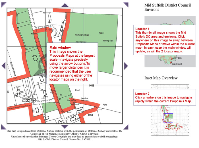
The Proposals and Inset Maps can be accessed by clicking on the ‘Proposals Maps’ link in the header bar. There are 2 ways to access the maps - either select a map via the ‘drop down menu' or click on the 'Mid Suffolk District Environs' map image. Either method will take you to an opening image of the Proposals or Inset Map - click on the image to progress into the 'Map Window'.
In the Main Map Window (shown below) the 'locator' map on the top right shows the geographical location of the main map image within Mid Suffolk District. The lower 'locator' map shows the geographical location of the main map image within the particular Proposals or Inset Map. You can navigate around the currently selected map sheet or inset map by using the arrows located around the main map image. By clicking on these, the next ‘map tile’ in that direction will appear. For moving larger distances you can click on the ‘Locator’ Map to the right. Please note that any movement of the main map image will be correspondingly matched by the blue locator on the ‘Locator’ Map(s).
The header bar contains a link to the ‘Key’ page. On selection a new window will appear showing all the colours and styles used in the mapping to represent the policies featured within the Local Plan. This is a useful guide when identifying policies shown on the maps. It is recommended that you leave this window open whilst navigating the mapping section of the Local Plan.